Showing posts with label Cuba. Show all posts

Wednesday, September 10, 2008

Hurricane Ike laying claim on Gulf of Mexico

It is still there!

Hurricane Ike didn't disappear last night.

In fact, it start spinning up the Gulf of Mexico and claiming it as its own.

I start the day out with a new graphic -- looks familiar doesn't it? The difference is there is no track down the center. I'm wondering if this is not a more accurate representation of what we know. Hurricanes rarely follow the line down the middle, but they do often stay within the cone of uncertainty. This gives a better picture to me of who ought to be taking serious preparations at this time.

Just a thought.

Click on the graphic above from the National Hurricane Center to get all the coordinates and such. A couple of things caught my attention:
  • the storm turned to a NW heading over night -- which if it holds up will take it more into the center of the Gulf
  • the storm has slowed down to 8 mph. Seems to me, the faster it moves, that harder it is for it to take sharp turns.
  • Winds are picking up -- 85 mph now.

You want to see how big this thing is getting, view this NOAA hi-res shot.

You can still see the storm pretty good on the Casablanca, Cuba radar, which to me is amazing considering the hit the upper end of Cuba took and continues to take.

--steve buser


Tuesday, September 9, 2008

Strange coincidence -- 11 days apart, same place

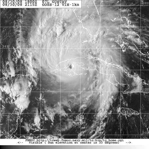
If you are one of those people who like strange coincidences, you're are going to LOVE this one: (picture above is Hurricane Ike below is Gustav)

1. Hurricane Ike's latest advisory
AT 200 PM EDT...1800Z...
THE CENTER OF HURRICANE IKE
WAS LOCATED INLAND OVER WESTERN CUBA NEAR
LATITUDE 22.7 NORTH...
LONGITUDE 83.4 WEST


OR ABOUT 65 MILES...105 KM...
WEST-SOUTHWEST OF HAVANA CUBA.

2. Hurricane Gustav's advisory
from 11 days ago --
AT 800 PM EDT...0000Z...
THE EYE OF HURRICANE
GUSTAV WAS LOCATED
NEAR
LATITUDE 22.7 NORTH...
LONGITUDE 83.4 WEST
.
THIS POSITION IS
OVER WESTERN CUBA NEAR
LOS PALACIOS

AND ABOUT 65 MILES...105 KM...
WEST-SOUTHWEST OF HAVANA.

Same place over Cuba. Same coordinates.

Of course, the predicted tracts are totally different and Gustav's winds were at 150 mph, making Ike's 80 mph winds seem weak.

The picture of Gustav on the left was from a few hours before it reached the place we are talking about here. I just couldn't find an archive shot at exactly the right hour

-- steve buser

Hurricane Ike seems to like lower Texas coast

The New Orleans Region is out!

The new model runs set the sites of Hurricane Ike on the lower Texas coast and Louisiana's coast line including the New Orleans region is no longer in the cone of uncertainty.

The storm is having a tough time with the Cuban coastline as it pushes its way through the Golfo de Matamano.

It is aiming over the Sierra de la Guira -- a favorite bird watching area and preserve with pine, cedar and mahogany forests. It will apparently pass almost directly over San Diego de la Banos.

You can watch its progress on this radar on the Isle of Pines, just across the bay from the center of the storm. Or from Casblanca, Cuba radar which shows the lower Florida coast which is getting bands from the storm as it passes by.

Of course, the National Weather Service radar in Miami gives the same view from the U.S. side.

--steve buser

Monday, September 8, 2008

Hurricane Ike losing strength strafing Cuba shores


Old Hurricane Ike is still sliding along the Cuban coast and losing strength doing it.

At 10 p.m. our time the center of Hurricane Ike was located near latitude 21.8N longitude 80.8W -- in the Gulfo de Cazones, 2o miles south of Playa Giron and Bahía del Cochinos (Bay of Pigs) on the south coast of Cuba 140 miles southeast of Havana. Sustained winds are at a 80 mph maximum and forward speed slipped slightly to 13 mph.

The storm was ravelled by its pass over Cuba even though it escaped the highest mountains. Central pressure has risen to 967 milibars and hurricane force winds now only extend 35 miles from the center.

For your historical interest, the Bay of Pigs was the site of a 1961 U.S.-backed invasion by 1200 Cuban exiles and supporters that failed to overthrow President Fidel Castro's government. The survivors were later traded to the US for $53 million in medicine and money.

On its way toward this spot Ike's center passed just to the south of the city of Cienfuegos --one of Cuba's chief seaports (center of sugar trade, coffee and and tobacco) the farming region around Cienfuegos (literally 100 fires) is a chief sugar cane and coffee growing region. ( I can see a story coming about this effect on the world market because of the effect of Gustav on US sugar cane crops).

The picture above is the the state hotel in Cienfuegos. (Photo by Dirk van der Made)

Below, the picture is of a beach on the island of Cargo Largo del Sur -- on the south edge of the Gulfo de Cazones where Hurricane Ike is now passing.

--steve buser

Ike slides along Cuban coast -- Texas is the bullseye


The new Hurricane Ike path from NOAA keeps New Orleans just on the edge of the cone of error. The Central Texas Coast is in the center. This puts a real burden on the Houston and Corpus Christi areas to keep and eye on the storm but pushes back likely landfall to Saturday.

Cuba is also taking its toll on the storm with the maximum sustained winds down to 85 mph.

Weather in the Keys
The winds are starting to pick up in the Florida Keys with the Sombrero Key buoy reporting 28kt sustained winds and long key reporting 22kt winds. Sand Key, the furthest buoy on the strand out from the mainland is reporting 31kts winds.

Real Time Buoy data
Here's some real time buoy data from the west side of the storm.

--steve buser

Hurricane Ike slides back into hot water

Hurricane Ike has been holding steady at about the 2.1 latitude mark for the past 24 hours. For that matter it is has basically been on that track for several days. That is a direct west heading.

The forecast calls for a turn slightly to the north to follow Cuba. It is not out of the realm now that it will go along Cuba's south shore over the water. It went in a straight diagonal path west across Cuba, hitting the third largest city Camaguey, a large dairy center , where the radar is now out of service.

It has emerged into a shallow coastal bay that is protected by barrier islands. The latest National Hurricane Center Advisory still has it as a category 2 storm with 100 miles per hour winds and heading due west at 14 mph. It expects it to slide up the Cuba, now though, much of that sliding may be over open water (of sorts).

Though, Camaguey radar is out, you can still track the storm with the Pico de San Juan radar from Cuba.

You can now watch the storm approaching (in about 36 hours) from a Key West, Florida beach cam. And this cam at Mallory Square

Governor Bobby Jindal declares emergency for Louisiana as Ike approaches


Here's NOAA's latest high resolution picture of Ike just crossing Cuba


Hurricane Ike sweeps across lower Cuba

Hurricane Ike appears ready to emerge back over water after cutting across the middle third of Cuba during the night.

Wide satellite imagery shows outflow bands from Hurricane Ike beginning to sweep across southern Florida.

The 7 am CDT advisory from the National Hurricane center puts the center of Hurricane Ike at Latitude 21.1 North and Longitude 77.9 West -- 20 miles directly south of Camaquey, Cuba's third largest city. It is moving west near 14 mph and a west to west-northwest motion is expected over the next day or two. "

"On this track the center of Ike will move over or very near central Cuba today ... and
emerge into the Southeastern Gulf of Mexico by late Tuesday."

MAXIMUM SUSTAINED WINDS HAVE DECREASED TO NEAR 100 MPH...155
KM/HR...WITH HIGHER GUSTS. IKE IS A CATEGORY TWO HURRICANE ON THE
SAFFIR-SIMPSON SCALE. ADDITIONAL WEAKENING IS FORECAST AS IKE MOVES
OVER CENTRAL CUBA TODAY.

HURRICANE FORCE WINDS EXTEND OUTWARD UP TO 60 MILES...95 KM...FROM
THE CENTER...AND TROPICAL STORM FORCE WINDS EXTEND OUTWARD UP TO 200
MILES...325 KM. THE ESTIMATED MINIMUM CENTRAL PRESSURE IS 960 MB...28.35 INCHES.

Hurricane Ike makes landfall in Cuba

The latest prediction by NOAA and the National Weather Service puts Hurricane Ike in the center of the Gulf this Thursday night with a brush past New Orleans and a bead on the upper Texas Coast. The cone of error however is still quite large extending from Pensacola to the Brownsville, TX.

Meanwhile, Hurricane Ike made is second landfall, this time in Cuba near the town of Puerto Padre. (Weather Underground's page for Puerto Padre)

Camagüey, the third largest city of Cuba with a population of 324,921 seems to be the next largest city in the path of Hurricane Ike.

The photo of Camagüey on the left (photo by Danelo) shows Iglesia San Francisco (right) and Estadio Cándido González (background, center)

Camagüey Radar

Pico de San Juan Radar

--steve buser


Salient parts of the 2:oo a.m EDT ( 1:oo a.m. here) :
TNT34 KNHC 080555
TCPAT4
BULLETIN
HURRICANE IKE INTERMEDIATE ADVISORY NUMBER 28A
NWS TPC/NATIONAL HURRICANE CENTER MIAMI FL AL092008
200 AM EDT MON SEP 08 2008

...IKE JUST INLAND OVER EASTERN CUBA...

....

A HURRICANE WARNING REMAINS IN EFFECT FOR THE CUBA FROM THE PROVINCE OF GUANTANAMO WESTWARD THROUGH MATANZAS. PREPARATIONS TO PROTECT LIFE AND PROPERTY SHOULD BE RUSHED TO COMPLETION.

A HURRICANE WATCH IS IN EFFECT FOR THE CUBAN PROVINCES OF LA HABANA...CIUDAD DE HABANA...PINAR DEL RIO...AND THE ISLE OF YOUTH.

A HURRICANE WATCH IS IN EFFECT FOR THE FLORIDA KEYS FROM OCEAN REEF WESTWARD...INCLUDING THE DRY TORTUGAS.

A TROPICAL STORM WATCH REMAINS IN EFFECT FOR JAMAICA AND THE CAYMAN ISLANDS.

ALL INTERESTS IN THE NORTHWEST BAHAMAS AND SOUTH FLORIDA SHOULD CLOSELY MONITOR THE PROGRESS OF THIS HURRICANE.

FOR STORM INFORMATION SPECIFIC TO YOUR AREA...INCLUDING POSSIBLE INLAND WATCHES AND WARNINGS...PLEASE MONITOR PRODUCTS ISSUED BY YOUR LOCAL WEATHER OFFICE.

AT 200 AM EDT...0600Z...THE CENTER OF HURRICANE IKE WAS LOCATED NEAR LATITUDE 21.2 NORTH...LONGITUDE 76.6 WEST OR JUST INLAND NEAR THE THE NORTH COAST OF EASTERN CUBA IN THE PROVINCE OF LAS TUNAS. THIS POSITION IS 85 MILES...135 KM...EAST OF CAMAGUEY.

IKE IS MOVING TOWARD THE WEST NEAR 14 MPH...23 KM/HR...AND A WEST TO WEST-NORTHWEST MOTION IS EXPECTED OVER THE NEXT DAY OR TWO. ON THIS TRACK THE CENTER OF IKE WILL MOVE OVER MUCH OF CENTRAL CUBA TODAY...AND BE NEAR OR OVER WESTERN CUBA ON TUESDAY.

MAXIMUM SUSTAINED WINDS ARE NEAR 120 MPH...195 KM/HR...WITH HIGHER GUSTS. IKE IS A CATEGORY THREE HURRICANE ON THE SAFFIR-SIMPSON SCALE. WEAKENING IS LIKELY AS IKE MOVES OVER CUBA DURING THE NEXT DAY OR SO.

HURRICANE FORCE WINDS EXTEND OUTWARD UP TO 60 MILES...95 KM...FROM THE CENTER...AND TROPICAL STORM FORCE WINDS EXTEND OUTWARD UP TO 140 MILES...220 KM.

ESTIMATED MINIMUM CENTRAL PRESSURE IS 945 MB...27.91 INCHES.

STORM SURGE FLOODING OF 9 TO 12 FEET ABOVE NORMAL TIDE LEVELS... ALONG WITH LARGE AND DANGEROUS BATTERING WAVES...CAN BE EXPECTED WITHIN THE WARNING AREA IN AREAS OF ONSHORE WINDS.

LARGE SWELLS GENERATED BY IKE WILL AFFECT PORTIONS OF THE SOUTHEAST UNITED STATES COAST DURING THE NEXT COUPLE OF DAYS. THESE WAVES COULD GENERATE DANGEROUS AND LIFE-THREATENING RIP CURRENTS.

IKE IS EXPECTED TO PRODUCE RAINFALL ACCUMULATIONS OF 6 TO 12 INCHES OVER EASTERN AND CENTRAL CUBA...WITH ISOLATED MAXIMUM AMOUNTS OF UP TO 20 INCHES POSSIBLE. THESE RAINS ARE LIKELY TO CAUSE LIFE- THREATENING FLASH FLOODS AND MUD SLIDES OVER MOUNTAINOUS TERRAIN. RAINFALL TOTALS OF 4 TO 8 INCHES ARE POSSIBLE IN THE SOUTHERN
BAHAMAS. PORTIONS OF HISPANIOLA COULD RECEIVE ADDITIONAL AMOUNTS OF 3 TO 5 INCHES. ADDITIONAL RAINFALL AMOUNTS OF 2 TO 4 INCHES ARE POSSIBLE OVER THE TURKS AND CAICOS ISLANDS. RAINFALL ACCUMULATIONS OF 1 TO 3 INCHES ARE POSSIBLE OVER THE FLORIDA KEYS.
...

$$
FORECASTER FRANKLIN

Sunday, September 7, 2008

Hurricane Ike jogs to west?

The latest Satellite loop for Hurricane Ike shows it changing directions to the west and apparently staying off the coast of Cuba for a while. That could be a spoiler for the theory that travelling over the length of Cuba will weaken Ike.


The latest advisory on the storm from the National Hurricane Center:
WTNT34 KNHC 071801
TCPAT4
BULLETIN
HURRICANE IKE INTERMEDIATE ADVISORY NUMBER 26A...CORRECTED
NWS TPC/NATIONAL HURRICANE CENTER MIAMI FL AL092008
200 PM EDT SUN SEP 07 2008

...CORRECTED FOR TIME...

...EYE OF IKE JUST WEST OF GREAT INAGUA ISLAND...

A HURRICANE WARNING REMAINS IN EFFECT FOR THE TURKS AND CAICOS
ISLANDS AND THE SOUTHEASTERN BAHAMAS INCLUDING THE ACKLINS...
CROOKED ISLAND...THE INAGUAS...MAYAGUANA...AND THE RAGGED
ISLANDS...AND FOR THE CENTRAL BAHAMAS INCLUDING CAT ISLAND...THE
EXUMAS...LONG ISLAND...RUM CAY...AND SAN SALVADOR.

A HURRICANE WARNING IS IN EFFECT FOR THE CUBAN PROVINCES OF VILLA
CLARA...SANCTI SPIRITUS...AND CIENFUEGOS. A HURRICANE WARNING IS
NOW IN EFFECT FOR THE CUBAN PROVINCES OF GUANTANAMO...SANTIAGO DE
CUBA... HOLGUIN...LAS TUNAS AND GRANMA...CAMAGUEY...CIEGO DE
AVILA....VILLA CLARA...SANCTI SPIRITUS...AND CIENFUEGOS. A
HURRICANE WARNING MEANS THAT HURRICANE CONDITIONS ARE EXPECTED
WITHIN THE WARNING AREA WITHIN THE NEXT 24 HOURS. PREPARATIONS TO
PROTECT LIFE AND PROPERTY SHOULD BE RUSHED TO COMPLETION.

A HURRICANE WATCH IS IN EFFECT FOR THE CUBAN PROVINCES OF
MATANZAS...LA HABANA...AND CIUDAD DE HABANA. A HURRICANE WATCH
MEANS THAT HURRICANE CONDITIONS ARE POSSIBLE WITHIN THE WATCH
AREA...GENERALLY WITHIN 36 HOURS.

A HURRICANE WATCH IS IN EFFECT FOR THE FLORIDA KEYS FROM OCEAN REEF
SOUTHWARD...INCLUDING THE DRY TORTUGAS.

A HURRICANE WATCH REMAINS IN EFFECT FOR ANDROS ISLAND IN THE
BAHAMAS.

A TROPICAL STORM WARNING IS IN EFFECT FOR THE NORTHERN
PENINSULA OF HAITI FROM THE NORTHERN BOARDER WITH THE DOMINICAN
REPUBLIC TO GONAIVES.

A TROPICAL STORM WATCH REMAINS IN EFFECT FOR THE CAYMAN ISLANDS.

ALL INTERESTS IN THE REMAINDER OF THE BAHAMAS...CUBA...AND SOUTH
FLORIDA SHOULD CLOSELY MONITOR THE PROGRESS OF THIS POTENTIALLY
DANGEROUS HURRICANE.

FOR STORM INFORMATION SPECIFIC TO YOUR AREA...INCLUDING POSSIBLE
INLAND WATCHES AND WARNINGS...PLEASE MONITOR PRODUCTS ISSUED
BY YOUR LOCAL WEATHER OFFICE.

AT 200 PM EDT...1800Z...THE CENTER OF HURRICANE IKE WAS LOCATED
NEAR LATITUDE 20.9 NORTH...LONGITUDE 74.0 WEST OR JUST WEST OF GREAT
INAGUA ISLAND AND ABOUT 90 MILES...155 KM...EAST-NORTHEAST OF
GUANTANAMO CUBA.

IKE IS MOVING TOWARD THE WEST NEAR 13 MPH...21 KM/HR. A WEST TO
WEST-SOUTHWEST MOTION IS EXPECTED TO CONTINUE THIS AFTERNOON WITH A
TURN TOWARD THE WEST-NORTHWEST EXPECTED ON MONDAY. ON THIS
TRACK...THE CORE OF THE HURRICANE WILL MOVE AWAY FROM THE
SOUTHEASTERN BAHAMAS THIS AFTERNOON AND MOVE NEAR OR OVER EASTERN
CUBA TONIGHT...AND NEAR OR OVER CENTRAL CUBA LATE MONDAY.

MAXIMUM SUSTAINED WINDS ARE NEAR 135 MPH...215 KM/HR...WITH HIGHER
GUSTS. IKE IS AN EXTREMELY DANGEROUS CATEGORY FOUR HURRICANE ON THE
SAFFIR-SIMPSON SCALE. FLUCTUATIONS IN STRENGTH ARE POSSIBLE THIS
AFTERNOON AND TONIGHT BUT IKE IS EXPECTED TO REMAIN A MAJOR
HURRICANE AS IT APPROACHES EASTERN CUBA. IKE IS EXPECTED TO WEAKEN
AS IT MOVES OVER EASTERN AND CENTRAL CUBA ON MONDAY.

HURRICANE FORCE WINDS EXTEND OUTWARD UP TO 60 MILES...95 KM...FROM
THE CENTER...AND TROPICAL STORM FORCE WINDS EXTEND OUTWARD UP TO 145
MILES...230 KM.

THE ESTIMATED MINIMUM CENTRAL PRESSURE IS 949 MB...28.02 INCHES.

STORM SURGE FLOODING OF 13 TO 18 FEET ABOVE NORMAL TIDE LEVELS...
ALONG WITH LARGE AND DANGEROUS BATTERING WAVES...CAN BE
EXPECTED WITHIN THE WARNING AREA IN AREAS OF ONSHORE FLOW.

LARGE SWELLS GENERATED BY IKE WILL AFFECT PORTIONS OF THE SOUTHEAST
UNITED STATES COAST DURING THE NEXT COUPLE OF DAYS. THESE WAVES
COULD GENERATE DANGEROUS AND LIFE-THREATENING RIP CURRENTS.

RAINFALL AMOUNTS OF 4 TO 8 INCHES WITH ISOLATED MAXIMUM AMOUNTS OF
12 INCHES ARE EXPECTED OVER THE TURKS AND CAICOS ISLANDS AND THE
SOUTHEASTERN BAHAMAS. HISPANIOLA...AND EASTERN AND CENTRAL CUBA
COULD SEE 6 TO 12 INCHES OF RAIN WITH ISOLATED MAXIMUM AMOUNTS OF
UP TO 20 INCHES POSSIBLE. THESE RAINS WILL LIKELY CAUSE
LIFE-THREATENING FLASH FLOODS AND MUDSLIDES OVER MOUNTAINOUS
TERRAIN.

REPEATING THE 200 PM EDT POSITION...20.9 N...74.0 W. MOVEMENT
TOWARD...WEST NEAR 13 MPH. MAXIMUM SUSTAINED WINDS...135 MPH.
MINIMUM CENTRAL PRESSURE...949 MB.

THE NEXT ADVISORY WILL BE ISSUED BY THE NATIONAL HURRICANE
CENTER AT 500 PM EDT.

$$
FORECASTER RHOME/BEVEN